Dataset
Total Ozone Mapping Spectrometer (TOMS): Meteor-3 ozone and reflectivity measurements (1991-1994)
Update Frequency: Not Planned
Latest Data Update: 1999-03-27
Status: Completed
Online Status: ONLINE
Publication State: Published
Publication Date: 2007-01-15
Download Stats: last 12 months
Dataset Size: 2.68K Files | 277MB
Abstract
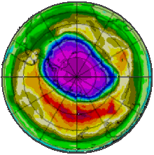
Data from the Total Ozone Mapping Spectrometer (TOMS), which used backscattered ultraviolet radiance to infer total column ozone measurements (gridded daily for the entire globe).This CD-ROM contains the latest version (version 7) of ozone and reflectivity data from the TOMS (Total Ozone Mapping Spectrometer) instrument onboard the Russian Meteor-3 spacecraft. Data covering the entire Meteor-3 TOMS lifetime, August 22, 1991 through December 27, 1994, are given as daily files of gridded data, as zonal means, and as overpass data.
Citable as: National Aeronautics and Space Administration; Mc.Peters, R. (2007): Total Ozone Mapping Spectrometer (TOMS): Meteor-3 ozone and reflectivity measurements (1991-1994). NCAS British Atmospheric Data Centre, date of citation. https://catalogue.ceda.ac.uk/uuid/00e2ba205fd43a390c168841c3ca8aa3
Abbreviation: Not defined
Keywords: ATMOSPHERICRADIATION, ATMOSPHERE, ATMOSPHERICCHEMISTRY
Details
| Previous Info: |
No news update for this record
|
|---|---|
| Previously used record identifiers: |
http://badc.nerc.ac.uk/view/badc.nerc.ac.uk__ATOM__dep_11688983940712460
|
| Access rules: |
Public data: access to these data is available to both registered and non-registered users.
Use of these data is covered by the following licence: http://www.nationalarchives.gov.uk/doc/open-government-licence/version/3/. When using these data you must cite them correctly using the citation given on the CEDA Data Catalogue record. |
| Data lineage: |
Data collected by NASA's Total Ozone Mapping Spectrometer (TOMS) and published on CD-ROM. A copy of the data were obtained by the BADC to assist in data access and to ensure long term preservation. |
| Data Quality: |
Data were prepared by NASA. Check documentation for further details
|
| File Format: |
Data are ASCII formatted
|
Related Documents
Process overview
This dataset was generated by a combination of instruments deployed on platforms
and computations as detailed below.
Instrument/Platform pairings
| Meteor-3 Total Ozone Mapping Spectrometer (TOMS) | Deployed on: Meteor-3 satellite |
Mobile platform operations
| Mobile Platform Operation 1 | Mobile Platform Operation for: Meteor-3 satellite |
Computation Element: 1
| Title | DETAILS NEEDED - COMPUTATION CREATED FOR SATELLITE COMPOSITE. deployed on Meteor-3 satellite |
| Abstract | This computation involved: DETAILS NEEDED - COMPUTATION CREATED FOR SATELLITE COMPOSITE. deployed on Meteor-3 satellite. The Meteor craft are weather observation satellites launched by the USSR. The Meteor satellites were designed to monitor atmospheric and sea-surface temperatures, humidity, radiation, sea ice conditions, snow-cover, and clouds.Meteor-3 was launched on August 15, 1991 from Plesetsk, Russia, and failed on 27th December 1994. Meteor-3 carried the second Total Ozone Mapping Spectrometer (TOMS) aloft as the first and the last American-built instrument to fly on a Soviet spacecraft. |
| Input Description | None |
| Output Description | None |
| Software Reference | None |
| Output Description | None |
- long_name: Oxygen Compounds
- names: Oxygen Compounds
- long_name: Ozone
- gcmd_url: http://vocab.ndg.nerc.ac.uk/term/P041/4/G164
- gcmd_keyword: EARTH SCIENCE > Atmosphere > Atmospheric Chemistry/Oxygen Compounds > Ozone
- names: EARTH SCIENCE > Atmosphere > Atmospheric Chemistry/Oxygen Compounds > Ozone, http://vocab.ndg.nerc.ac.uk/term/P041/4/G164
- long_name: Total Ozone Column
- names: Total Ozone Column
- long_name: Ultraviolet Radiation
- gcmd_url: http://vocab.ndg.nerc.ac.uk/term/P141/4/GVAR0907
- gcmd_keyword: Ultraviolet Radiation
- names: Ultraviolet Radiation, http://vocab.ndg.nerc.ac.uk/term/P141/4/GVAR0907
Co-ordinate Variables
Coverage
Temporal Range
Start time:
1991-08-21T23:00:00
End time:
1994-11-24T00:00:00
Geographic Extent
90.0000° |
||
-180.0000° |
180.0000° |
|
-90.0000° |
Related parties

