Dataset

HadISDH.land: gridded global monthly land surface humidity data version 4.4.0.2021f
Abstract
This is the HadISDH.land 4.4.0.2021f version of the Met Office Hadley Centre Integrated Surface Dataset of Humidity (HadISDH). HadISDH.land is a near-global gridded monthly mean land surface humidity climate monitoring product. It is created from in situ observations of air temperature and dew point temperature from weather stations. The observations have been quality controlled and homogenised. Uncertainty estimates for observation issues and gridbox sampling are provided (see data quality statement section below). The data are provided by the Met Office Hadley Centre and this version spans 1/1/1973 to 31/12/2021.
The data are monthly gridded (5 degree by 5 degree) fields. Products are available for temperature and six humidity variables: specific humidity (q), relative humidity (RH), dew point temperature (Td), wet bulb temperature (Tw), vapour pressure (e), dew point depression (DPD).
This version extends the previous version to the end of 2021. Users are advised to read the update document in the Docs section for full details on all changes from the previous release.
As in previous years, the annual scrape of NOAAs Integrated Surface Dataset for HadISD.3.1.2.202101p, which is the basis of HadISDH.land, has pulled through some historical changes to stations. This, and the additional year of data, results in small changes to station selection. The homogeneity adjustments differ slightly due to sensitivity to the addition and loss of stations, historical changes to stations previously included and the additional 12 months of data.
To keep informed about updates, news and announcements follow the HadOBS team on twitter @metofficeHadOBS.
For more detailed information e.g bug fixes, routine updates and other exploratory analysis, see the HadISDH blog: http://hadisdh.blogspot.co.uk/
References:
When using the dataset in a paper please cite the following papers (see Docs for link
to the publications) and this dataset (using the "citable as" reference):
Willett, K. M., Dunn, R. J. H., Thorne, P. W., Bell, S., de Podesta, M., Parker, D. E.,
Jones, P. D., and Williams Jr., C. N.: HadISDH land surface multi-variable humidity and
temperature record for climate monitoring, Clim. Past, 10, 1983-2006,
doi:10.5194/cp-10-1983-2014, 2014.
Dunn, R. J. H., et al. 2016: Expanding HadISD: quality-controlled, sub-daily station
data from 1931, Geoscientific Instrumentation, Methods and Data Systems, 5, 473-491.
Smith, A., N. Lott, and R. Vose, 2011: The Integrated Surface Database: Recent
Developments and Partnerships. Bulletin of the American Meteorological Society, 92,
704-708, doi:10.1175/2011BAMS3015.1
We strongly recommend that you read these papers before making use of the data, more
detail on the dataset can be found in an earlier publication:
Willett, K. M., Williams Jr., C. N., Dunn, R. J. H., Thorne, P. W., Bell, S., de
Podesta, M., Jones, P. D., and Parker D. E., 2013: HadISDH: An updated land surface
specific humidity product for climate monitoring. Climate of the Past, 9, 657-677,
doi:10.5194/cp-9-657-2013.
Details
| Previous Info: |
No news update for this record
|
|---|---|
| Previously used record identifiers: |
No related previous identifiers.
|
| Access rules: |
Public data: access to these data is available to both registered and non-registered users.
Use of these data is covered by the following licence(s): http://www.nationalarchives.gov.uk/doc/non-commercial-government-licence/version/2/ When using these data you must cite them correctly using the citation given on the CEDA Data Catalogue record. |
| Data lineage: |
HadISDH.land is a global land surface (~2 m) humidity dataset and is produced by the Met Office Hadley Centre in collaboration with Maynooth University, NOAA NCEI, NPL and CRU. It is based on the quality controlled sub-daily HadISD from the Met Office Hadley Centre which is in turn based on the ISD dataset from NOAA's NCEI. It is passed to CEDA for archiving and distribution. |
| Data Quality: |
Uncertainty estimates are provided as part of the dataset both at the station and gridbox level, this includes information covering station uncertainty (climatological, homogenisation and measurement uncertainty), gridbox spatial and temporal sampling uncertainty and combined station and sampling uncertainty. See dataset associated documentation for full details.
|
| File Format: |
Data are netCDF formatted
|
Related Documents
Process overview
| Title | HadISDH.land: gridded global land surface humidity dataset produced by the Met Office Hadley Centre |
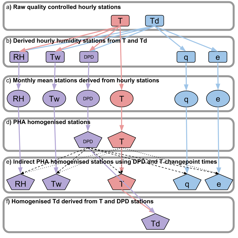
| Abstract | HadISDH.land utilises simultaneous subdaily temperature and dew point temperature data from over 3000 quality controlled HadISD stations that have sufficiently long records. All humidity variables are calculated at hourly resolution and monthly means are created. Monthly means are homogenised to detect and adjust for features within the data that do not appear to be of climate origin. While unlikely to be perfect, this process does help remove large errors from the data an improve robustness of long-term climate monitoring. The NCEI's Pairwise Homogenisation Algorithm has been used directly on DPD and T. An indirect PHA method (ID PHA) is used whereby changepoints detected in DPD and T are used to make adjustments to q, e, Tw and RH. Changepoints from DPD are also applied to T. Td is derived from homogenised T and DPD. See Docs 'HadISDH.land process diagram'. Station measurement, climatological and homogeneity adjustment uncertainties are estimated for each month. Climatological averages are calculated (the climatological period is dependent on product version) and monthly mean climate anomalies obtained. These anomalies (in addition to climatological mean and standard deviation, actual values and uncertainty components) are then averaged over 5° by 5° gridboxes centred on -177.5°W and -87.5°S to 177.5°E and 87.5°N. Given the uneven distribution of stations over time and space, sampling uncertainty is estimated for each gridbox month. For greater detail please see: and Willett, K. M., Williams Jr., C. N., Dunn, R. J. H., Thorne, P. W., Bell, S., de Podesta, M., Jones, P. D., and Parker D. E., 2013: HadISDH: An updated land surface specific humidity product for climate monitoring. Climate of the Past, 9, 657-677, doi:10.5194/cp-9-657-2013. Docs contains links to both these publications |
| Input Description | None |
| Output Description | None |
| Software Reference | None |
- units: 1
- long_name: actual number of stations within gridbox
- var_id: stncount
- names: actual number of stations within gridbox
- long_name: climatology period boundaries
- var_id: climbounds
- names: climatology period boundaries
- units: 1
- long_name: intersite correlation (rbar)
- var_id: rbar
- names: intersite correlation (rbar)
- units: hPa
- long_name: mean gridbox variance (sbar2)
- var_id: sbar2
- names: mean gridbox variance (sbar2)
- units: 1
- long_name: mean number of stations within gridbox
- var_id: meanstncount
- names: mean number of stations within gridbox
- var_id: month
- long_name: month of year
- names: month of year
- standard_name: air_temperature
- units: deg C
- var_id: tas
- long_name: near surface (~2m) air temperature
- names: air_temperature, near surface (~2m) air temperature
- units: deg C
- long_name: near surface (~2m) air temperature anomaly
- var_id: tasa
- names: near surface (~2m) air temperature anomaly
- units: deg C
- long_name: near surface (~2m) air temperature climatology
- var_id: clm
- names: near surface (~2m) air temperature climatology
- units: deg C
- long_name: near surface (~2m) air temperature standard deviation
- var_id: std
- names: near surface (~2m) air temperature standard deviation
- units: deg C
- standard_name: dew_point_depression
- var_id: dpds
- long_name: near surface (~2m) dewpoint depression
- names: dew_point_depression, near surface (~2m) dewpoint depression
- units: deg C
- var_id: dpdsa
- long_name: near surface (~2m) dewpoint depression anomaly
- names: near surface (~2m) dewpoint depression anomaly
- units: deg C
- var_id: clm
- long_name: near surface (~2m) dewpoint depression climatology
- names: near surface (~2m) dewpoint depression climatology
- units: deg C
- var_id: std
- long_name: near surface (~2m) dewpoint depression standard deviation
- names: near surface (~2m) dewpoint depression standard deviation
- units: deg C
- standard_name: dew_point_temperature
- var_id: tds
- long_name: near surface (~2m) dewpoint temperature
- names: dew_point_temperature, near surface (~2m) dewpoint temperature
- units: deg C
- var_id: tdsa
- long_name: near surface (~2m) dewpoint temperature anomaly
- names: near surface (~2m) dewpoint temperature anomaly
- units: deg C
- var_id: clm
- long_name: near surface (~2m) dewpoint temperature climatology
- names: near surface (~2m) dewpoint temperature climatology
- units: deg C
- var_id: std
- long_name: near surface (~2m) dewpoint temperature standard deviation
- names: near surface (~2m) dewpoint temperature standard deviation
- standard_name: relative_humidity
- var_id: hurs
- units: %rh
- long_name: near surface (~2m) relative humidity
- names: relative_humidity, near surface (~2m) relative humidity
- units: %rh
- long_name: near surface (~2m) relative humidity anomaly
- var_id: hursa
- names: near surface (~2m) relative humidity anomaly
- units: %rh
- var_id: clm
- long_name: near surface (~2m) relative humidity climatology
- names: near surface (~2m) relative humidity climatology
- units: %rh
- var_id: std
- long_name: near surface (~2m) relative humidity standard deviation
- names: near surface (~2m) relative humidity standard deviation
- units: g/kg
- standard_name: specific_humidity
- var_id: huss
- long_name: near surface (~2m) specific humidity
- names: specific_humidity, near surface (~2m) specific humidity
- units: g/kg
- long_name: near surface (~2m) specific humidity anomaly
- var_id: hussa
- names: near surface (~2m) specific humidity anomaly
- units: g/kg
- var_id: clm
- long_name: near surface (~2m) specific humidity climatology
- names: near surface (~2m) specific humidity climatology
- units: g/kg
- var_id: std
- long_name: near surface (~2m) specific humidity standard deviation
- names: near surface (~2m) specific humidity standard deviation
- units: hPa
- standard_name: water_vapor_partial_pressure_in_air
- var_id: vps
- long_name: near surface (~2m) vapor pressure
- names: water_vapor_partial_pressure_in_air, near surface (~2m) vapor pressure
- units: hPa
- var_id: vpsa
- long_name: near surface (~2m) vapor pressure anomaly
- names: near surface (~2m) vapor pressure anomaly
- units: hPa
- var_id: clm
- long_name: near surface (~2m) vapor pressure climatology
- names: near surface (~2m) vapor pressure climatology
- units: hPa
- var_id: std
- long_name: near surface (~2m) vapor pressure standard deviation
- names: near surface (~2m) vapor pressure standard deviation
- units: deg C
- standard_name: wet_bulb_temperature
- var_id: tws
- long_name: near surface (~2m) wetbulb temperature
- names: wet_bulb_temperature, near surface (~2m) wetbulb temperature
- units: deg C
- var_id: twsa
- long_name: near surface (~2m) wetbulb temperature anomaly
- names: near surface (~2m) wetbulb temperature anomaly
- units: deg C
- var_id: clm
- long_name: near surface (~2m) wetbulb temperature climatology
- names: near surface (~2m) wetbulb temperature climatology
- units: deg C
- var_id: std
- long_name: near surface (~2m) wetbulb temperature standard deviation
- names: near surface (~2m) wetbulb temperature standard deviation
- units: hPa
- var_id: adjunc
- long_name: uncorrelated 2 sigma adjustment uncertainty for gridbox
- names: uncorrelated 2 sigma adjustment uncertainty for gridbox
- units: hPa
- var_id: climunc
- long_name: uncorrelated 2 sigma climatology uncertainty for gridbox
- names: uncorrelated 2 sigma climatology uncertainty for gridbox
- units: hPa
- var_id: measunc
- long_name: uncorrelated 2 sigma measurement uncertainty for gridbox
- names: uncorrelated 2 sigma measurement uncertainty for gridbox
- units: hPa
- var_id: stnunc
- long_name: uncorrelated 2 sigma observation uncertainty for gridbox
- names: uncorrelated 2 sigma observation uncertainty for gridbox
- units: hPa
- var_id: sampunc
- long_name: uncorrelated 2 sigma sampling uncertainty for gridbox
- names: uncorrelated 2 sigma sampling uncertainty for gridbox
- units: hPa
- var_id: stdunc
- long_name: uncorrelated combined 2 sigma uncertainty for gridbox
- names: uncorrelated combined 2 sigma uncertainty for gridbox
Co-ordinate Variables
- units: degrees_north
- standard_name: latitude
- var_id: latitude
- long_name: gridbox centre latitude
- names: latitude, gridbox centre latitude
- units: degrees_east
- standard_name: longitude
- var_id: longitude
- long_name: gridbox centre longitude
- names: longitude, gridbox centre longitude
- standard_name: latitude
- var_id: bounds_lat
- long_name: latitude gridbox boundaries
- names: latitude, latitude gridbox boundaries
- standard_name: longitude
- var_id: bounds_lon
- long_name: longitude gridbox boundaries
- names: longitude, longitude gridbox boundaries
- long_name: time
- standard_name: time
- var_id: time
- names: time
- standard_name: time
- long_name: time period boundaries
- var_id: bounds_time
- names: time, time period boundaries
Temporal Range
1973-01-01T00:00:00
2021-12-31T23:59:59
Geographic Extent
90.0000° |
||
-180.0000° |
180.0000° |
|
-90.0000° |