Dataset
Total Ozone Mapping Spectrometer (TOMS) measurements from Earth Probe (1996-2005)
Abstract
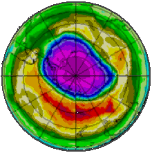
The Total Ozone Mapping Spectrometer (TOMS) is an instrument built and operated by the National Aeronautics and Space Administration (NASA). The instrument uses backscattered ultraviolet radiance to infer total column ozone measurements. The dataset consists of daily gridded averages of total ozone covering the entire globe, in the form of images, from NASA NIMBUS 7, Meteor-3, Earth Probe and ADEOS satellites. Data is from 1978 to 2006. The Ozone Monitoring Instrument (OMI) on the AURA spacecraft, OMI data of ozone are now available for the entire OMI mission. In addition to ozone data, OMI data for aerosol and reflectivity are available. These datasets are public.
Details
| Previous Info: |
No news update for this record
|
|---|---|
| Previously used record identifiers: |
http://badc.nerc.ac.uk/view/badc.nerc.ac.uk__ATOM__dep_11688985615412464
|
| Access rules: |
Public data: access to these data is available to both registered and non-registered users.
Use of these data is covered by the following licence(s): http://www.nationalarchives.gov.uk/doc/open-government-licence/version/3/ When using these data you must cite them correctly using the citation given on the CEDA Data Catalogue record. |
| Data lineage: |
Total Ozone Mapping Spectrometer (TOMS) data were mirrored from GSFC NASA until saturday December 2, 2006, when contact with Earth Probe was lost. |
| Data Quality: |
Data quality controlled by NASA.
TOMS - Total Calibration Error - The Version 8 algorithm is now used for all TOMS data. For data beginning in year 2000, the calibration has been stabilized relative to NOAA-16 SBUV/2 in the equatorial zone. Because of continuing changes in the optical properties of the front scan mirror that are not well understood, we are now seeing a latitude dependent error that cannot be corrected by a simple calibration correction. The calibration appears to be stable near the equator. But by 50 degrees latitude, there is now a -2% to -4% error in TOMS, a bit larger in the northern hemisphere than in the southern hemisphere. Because of this error, data since 2002 should NOT be used for trend analysis.
|
| File Format: |
Data are ASCII formatted
|
Process overview
Instrument/Platform pairings
| EP Total Ozone Mapping Spectrometer (TOMS) | Deployed on: Earth-Probe (EP) |
Mobile platform operations
| Mobile Platform Operation 1 | Mobile Platform Operation for: Earth-Probe (EP) |
Computation Element: 1
| Title | DETAILS NEEDED - COMPUTATION CREATED FOR SATELLITE COMPOSITE. deployed on Earth-Probe (EP) |
| Abstract | This computation involved: DETAILS NEEDED - COMPUTATION CREATED FOR SATELLITE COMPOSITE. deployed on Earth-Probe (EP). Earth-Probe TOMS was launched on 2nd July 1996 and started to produce data on 25th July. On Saturday, december 2, 2006, contact with Earth Probe was lost and it was put in SAFE mode. |
| Input Description | None |
| Output Description | None |
| Software Reference | None |
| Output Description | None |
- long_name: Oxygen Compounds
- names: Oxygen Compounds
- long_name: Ozone
- gcmd_url: http://vocab.ndg.nerc.ac.uk/term/P041/4/G164
- gcmd_keyword: EARTH SCIENCE > Atmosphere > Atmospheric Chemistry/Oxygen Compounds > Ozone
- names: EARTH SCIENCE > Atmosphere > Atmospheric Chemistry/Oxygen Compounds > Ozone, http://vocab.ndg.nerc.ac.uk/term/P041/4/G164
- long_name: Total Ozone Column
- names: Total Ozone Column
Co-ordinate Variables
Temporal Range
1996-07-24T23:00:00
2005-12-31T00:00:00
Geographic Extent
90.0000° |
||
-180.0000° |
180.0000° |
|
-90.0000° |

