Dataset
ERBE: ERBE instrument measurements on aboard the Earth Radiation Budget Satellite (ERBS)
Abstract
This dataset consists of data from the Earth Radiation Budget Experiment (ERBE) instrument on the NASA Earth Radiation Budget Satellite (ERBS), launched from the Space Shuttle Challenger in October 1984 (STS-41G). ERBS was placed into an orbit at 603-km altitude, 57-deg. inclination.
The ERBE instrument's main aim was to provide accurate measurements of incoming solar energy and shortwave and longwave radiation reflected or emitted from the Earth back into space.
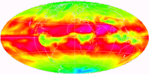
This dataset contains colour images (shortwave/longwave/net radiation, albedo, clear-sky albedo, clear-sky shortwave/longwave/net radiation, and shortwave/longwave/net cloud forcing) from the ERBE instrument, a scanning radiometer on ERBS.
Monthly average values are included for the time periods during which the scanners were operational.
This dataset is public, though NASA noted that this is intended for research purposes and the data has no commercial value.
Details
| Previous Info: |
No news update for this record
|
|---|---|
| Previously used record identifiers: |
http://badc.nerc.ac.uk/view/badc.nerc.ac.uk__ATOM__dep_11701747196413327
|
| Access rules: |
Public data: access to these data is available to both registered and non-registered users.
Use of these data is covered by the following licence(s): https://artefacts.ceda.ac.uk/licences/missing_licence.pdf When using these data you must cite them correctly using the citation given on the CEDA Data Catalogue record. |
| Data lineage: |
Data collected by NASA using the Earth Radiation Budget Satellite (ERBS), processed and prepared by NASA. A copy of the data were then obtained by the BADC to be made available through the BADC archive. |
| Data Quality: |
Data collected and processed by NASA prior to publication.
|
| File Format: |
Data are GIF formatted
|
Related Documents
Process overview
Instrument/Platform pairings
| Earth Radiation Budget Experiment (ERBE) | Deployed on: Earth Radiation Budget Satellite (ERBS) |
Mobile platform operations
| Mobile Platform Operation 1 | Mobile Platform Operation for: Earth Radiation Budget Satellite (ERBS) |
Computation Element: 1
| Title | deployed on Earth Radiation Budget Satellite (ERBS) |
| Abstract | This computation involved: deployed on Earth Radiation Budget Satellite (ERBS). |
| Input Description | None |
| Output Description | None |
| Software Reference | None |
| Output Description | None |
- long_name: Albedo
- gcmd_url: http://vocab.ndg.nerc.ac.uk/term/P041/4/G199
- gcmd_keyword: EARTH SCIENCE > Atmosphere > Atmospheric Radiation > Albedo
- names: EARTH SCIENCE > Atmosphere > Atmospheric Radiation > Albedo, http://vocab.ndg.nerc.ac.uk/term/P041/4/G199
- long_name: Incidence
- names: Incidence
- long_name: Net Radiation
- gcmd_url: http://vocab.ndg.nerc.ac.uk/term/P141/4/GVAR0546
- gcmd_keyword: Net Radiation
- names: Net Radiation, http://vocab.ndg.nerc.ac.uk/term/P141/4/GVAR0546
- long_name: Radiative Flux
- gcmd_url: http://vocab.ndg.nerc.ac.uk/term/P141/4/GVAR0677
- gcmd_keyword: Radiative Flux
- names: Radiative Flux, http://vocab.ndg.nerc.ac.uk/term/P141/4/GVAR0677
- long_name: Shortwave Radiation
- gcmd_url: http://vocab.ndg.nerc.ac.uk/term/P141/4/GVAR0755
- gcmd_keyword: Shortwave Radiation
- names: Shortwave Radiation, http://vocab.ndg.nerc.ac.uk/term/P141/4/GVAR0755
- long_name: Solar Irradiance
- gcmd_url: http://vocab.ndg.nerc.ac.uk/term/P141/4/GVAR0809
- gcmd_keyword: Solar Irradiance
- names: http://vocab.ndg.nerc.ac.uk/term/P141/4/GVAR0809, Solar Irradiance
Co-ordinate Variables
Temporal Range
1984-11-01T00:00:00
1990-02-28T00:00:00
Geographic Extent
90.0000° |
||
-180.0000° |
180.0000° |
|
-90.0000° |

